 I
In the early 1900's, Franconia Notch was not quite the notch we know and love today. The mountains were there of course, the lakes still sparkled, rivers raged and the stone faces protruding from the cliffs high above stoically watched over the affairs of mankind. There were hotels, as there are today, but not the ones we now spend the night in. There were once grand hotels located at the Flume, the base of Cannon Mountain, even a summit house atop the short but majestic Bald Mountain. With time, they disappeared, usually ravaged by fire. New hotels were constructed in easier to reach locations and the grand resorts became a thing of the past. But we lost more than a few impressive buildings, we lost a part of history.
For decades we thought The Old Man Of The Mountains watched over Franconia Notch alone. When he fell, we never thought about how it might affect his life long companion, The Old Lady Of The Mountains. We forgot she was even there. If it weren't for a few old post cards, we may not know she ever existed in the first place. She goes by many names but is most commonly referred to simply as The Watcher.
It is assumed there was once a trail that lead to the stone face high above the notch on Eagle Cliff. But if there was, we lost it over time. Perhaps we've gotten too lazy and don't care to see things we need to put effort into finding. It's much easier to drive by and look up than it is to actually go up. You can't exactly see The Watcher from the road, but once you know she's there, once you know where to look, you can't help but see her every time you pass through her notch. But to visit her firsthand, it's something you can't put into words. The beautiful danger of coming face to face with The Watcher is not for the faint of heart. I will tell you how to get there, but know this, if you do not respect the power of mother nature as well as your own limitations, both physical and mental, you may not live to tell the story.
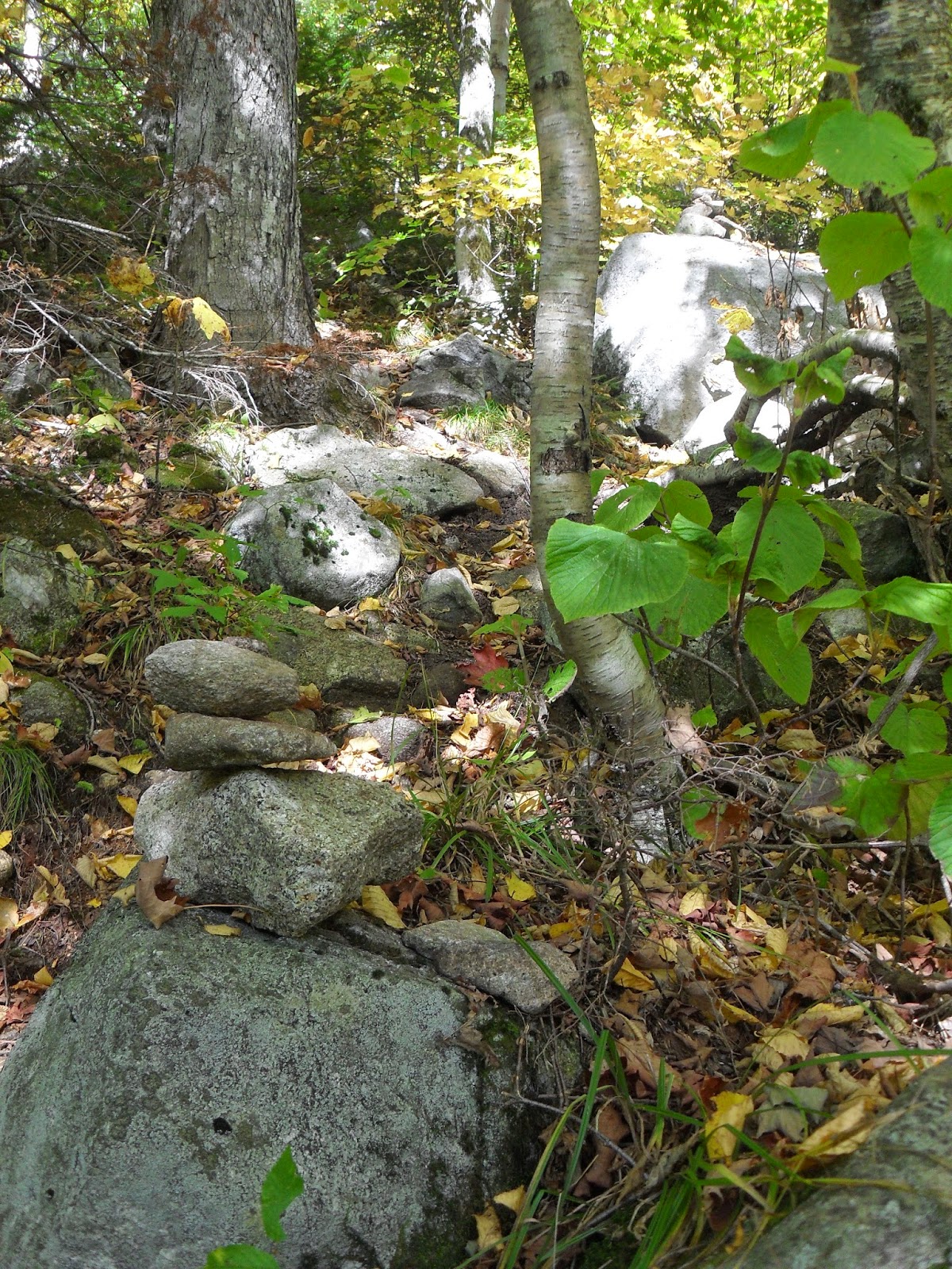
There is a trail to The Watcher, sort of. I do not know if this is the trail used over a hundred years ago by those who stayed at the Profile House but one thing is for certain, it brings us to the same destination, The Old Lady Of The Lake herself. The trail is easy enough to find, in fact it's located along the current Green Leaf trail that skirts the bottom of Eagle Cliff, eventually winding through Eagle's Pass and continuing up Mt Lafayette. If you aren't familiar with this less traveled trail up Mt Lafayette, it begins at the Cannon Mountain Tramway. Just walk under the bridge along the sidewalk and look to your left. There will be a trailhead a short ways up the ramp, that's the Green Leaf trail. Follow this easy part of the trail for approximately ten minutes and look for a lesser traveled trail on your left marked by a cairn. For those of you who don't know, a cairn is a small stack of rocks used to signify a trail. Without the cairn, the trail would appear to be nothing more than a dried up stream bed that crosses the path. If you miss the first one, there's another cairn a few feet ahead that will put you on the right track. From here, it gets pretty steep.

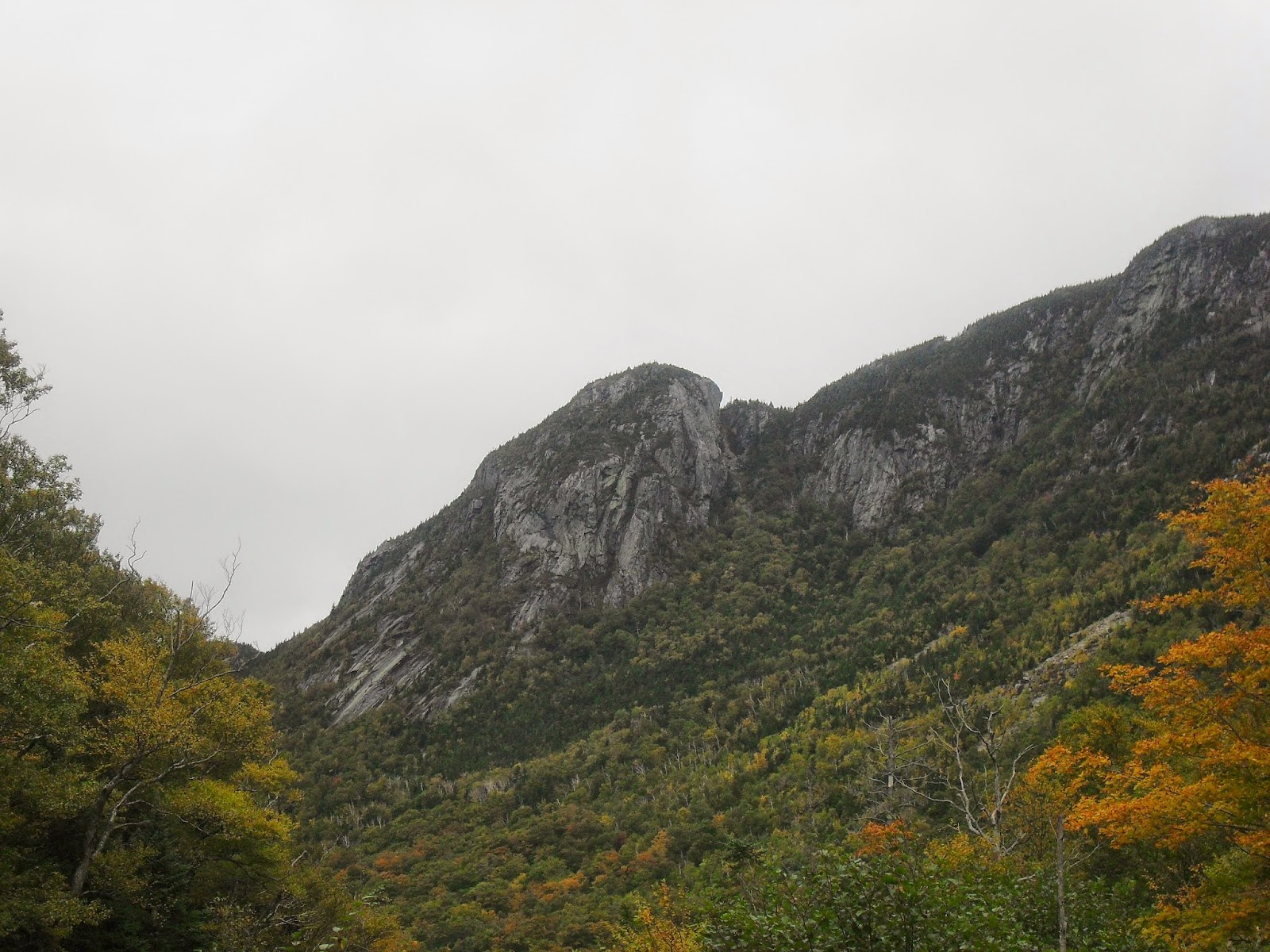
The trail you're following is not actually for hikers, it's a rock climbing trail that leads to something equally as impressive as The Watcher, a feat of nature known as The Eaglet. The Eaglet is a spire of rock unlike any other in New England to a point where maybe 'unlike' isn't the correct term. You see, it is the
only free standing rock spire on the entire East Coast, or so I'm told. I'm no geologist but to put it simply, we don't have rock formations like that around here. They belong out west. So naturally, any serious rock climber has to conquer the free standing spire of stone. Much like The Watcher, you can't quite see it from the road, but once you know it's there, you'll be slowing down traffic behind you every time you drive by, hoping to catch a glimpse of what few know is even there.
Remember, this is their trail, the rock climbers are the only ones who use it so respect it and always give them the right of way. On a weekend, there will almost always be a group or two heading out to conquer The Eaglet. That said, the trail is quite easy to follow. No blazes, it's not an official trail, but the path is well worn and marked by cairns quite frequently. It starts out like any other trail in Franconia Notch, lots of roots and rocks and boulders to walk around. The higher you get, the larger the boulders. This is where the trail begins to get tricky and small amounts of rock climbing are necessary. The rock climbers don't mind, it's just a little warmup for them. But the average hiker may have a little difficulty using nearby tree trunks and exposed roots to pull themselves up small rock ledges in the path.

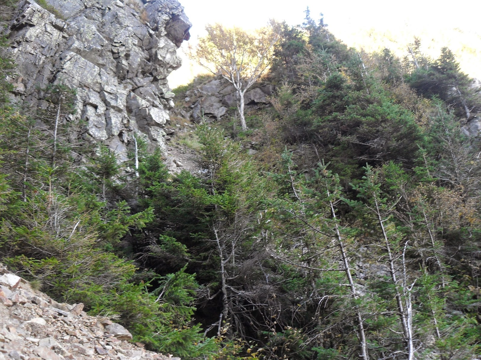
Then through the trees you spot the ledges looming overhead, the Eaglet rising 300 feet from the base of the impressive cliffs. You won't miss it, it sticks out like the beak of a falcon. Coincidentally, peregrine falcons call these ledges home instead of the eagles the cliff was named after. Standing on a boulder, gazing up at the free standing spire of stone knocked the air from my lungs. My knees trembled a little, okay a lot, so I can't imagine what it's like for those about to scale its granite walls.

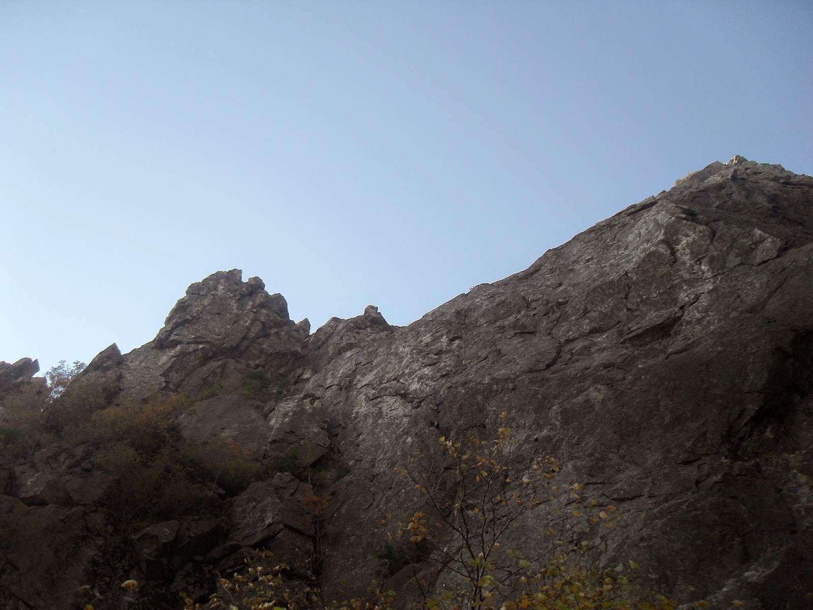
As you get closer, it loses its shape to the rock wall behind it and the skies above it. But you can't look up the entire time, the trail needs your full attention. The mountain is as steep as it looks from the road, usually demanding as many points of contact as possible on its unofficial trail. This means you want your hands holding onto a strong branch or jagged piece of rock whenever possible. It's a little tricky but nothing too strenuous, remember, rock climbers are doing it with heavy packs and tons of rope over their shoulder. The rocks here are surprisingly firmly set without much in the way of wiggling, let alone loose stones falling with your every step. I felt quite safe on this trail, that is until I passed The Eaglet.
.JPG "The Eaglet Spire on Eagle Cliff")
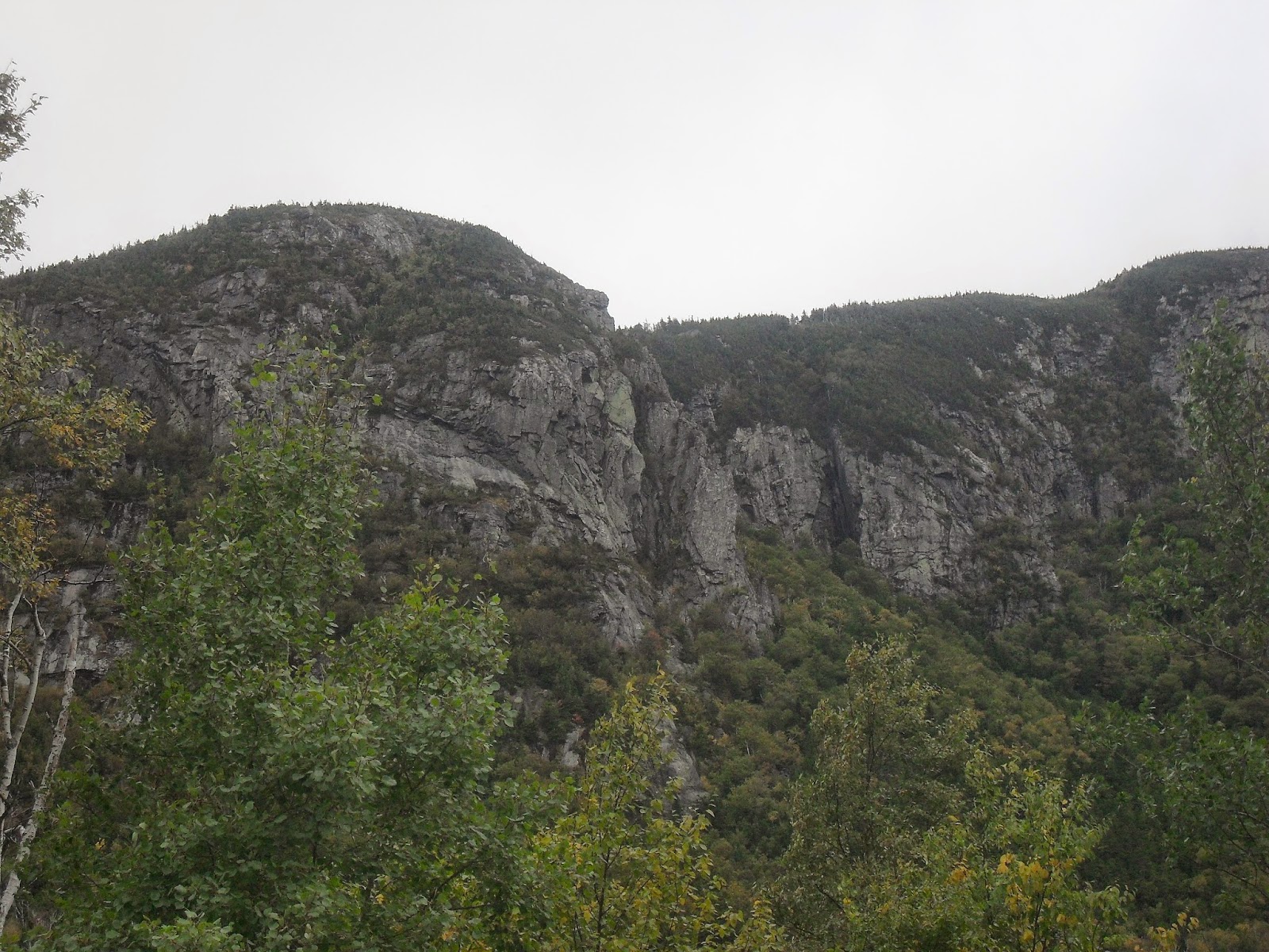
This is where the trail stops, not even because this is where most people leave it to climb the breath taking tower of rock, but because there's nowhere to stack a cairn or slap on a blaze of colorful paint. This is where the rock slide truly begins. Or perhaps ends, depending on how you look at it. It starts off moderately with a few larger stones for footing and trees respectable enough in size to hang onto. But with every step, the stones get smaller and the trees get more feeble. The Eaglet gets further from view, once again taking its spectacular shape. If the Old Man Of The Mountains hadn't fallen over ten years ago, the pictures from this vantage point would be iconic. It's at this point in the climb when The Watcher truly comes into view. She watches silently from her perch on the ledges before you, but I could hear her thinking it, "stupid humans, they were never meant to climb this high on my ledges".

The Watcher before you, The Eaglet behind you, cliffs to either side, unstable stones at your feet sliding out from beneath you with every subtle movement. I've been to many incredible places, none like this. There was a feeling of being somewhere I shouldn't have been. Somewhere I wasn't meant to be. It's that adrenaline rush that fuels your desire to go on. It is perhaps the most terrifying, breathtaking, beautiful, rugged and awe inspiring place I have ever been. So many emotions wrapped up in one 360 degree view.
I continued on, rounding the cliff, leaving The Eaglet behind me, blocked from sight. A smaller ledge to the right of The Watcher juts out into the rock slide, giving you the option of traveling up that side of it instead where the loose rocks looked ever so slightly larger. But I stuck to the left, going straight for The Watcher.
The stones I once used for leverage disappeared, leaving only the loose gravel. Every step was wasted as I'd slide down two, trying desperately to stop myself. The branches were useless to hold onto, they weren't even branches, they were merely twigs. It was here that I realized what a mistake I'd made. Going down this unbelievable slope would surely be impossible, my only hope was to make it to the top of the ridge and find another way down. I knew the bushwhacking would be difficult and steep and it would bring me out on the opposite side of the mountain from where my car was parked but there was nothing else to do. Going back down wasn't an option, from my precarious position rocks were sliding out from beneath my feet and tumbling down the steep and dangerous mountainside.
Every movement sent me sliding down the unstable terrain with nothing to stop my fall. This is where panic sets in, when you realize you've painted yourself into a corner. You can't go up, and you can't go down. There I stood, if you can call it standing, twenty feet from the crest of the ridge with no way to get there. I'd read about others doing it, perhaps they're braver than I am, braver or more idiotic, but I knew my limitations. Those last twenty feet were not happening. Then again, neither was my descent, not safely at least. I thought to myself, "if I make it down alive, this is my last hike". It occurred to me that we put ourselves in these positions, but can never really explain why. Exercise? No, we could just easily run on a treadmill. The view? No, I'd already seen it a few hundred feet lower. The thrill? No, I'm no thrill seeker, hell, I'm afraid of heights. I think it has something to do with conquering things greater than yourself. That's the only explanation for doing something so stupid yet rewarding.

I didn't make it to the top of the ridge. Did I fail? Not exactly, I only set out to see the two spectacular rock formations. Will not making it to the top haunt me? Yes, but it's better than being the one haunting the trail. I froze there, yes, in fear, but also because there was nothing else to do. Every movement put me in a deadly situation. I've lived an amazing life, I'm grateful for the past I made, but I can't wait for the future I still have yet to make. So, frozen there on the side of Eagle Cliff, I knew it wasn't the end for me. I rolled onto my back in the near vertical position, butt to the unstable stones beneath me, limbs spread, clawing at whatever they could find, and my eyes locked on the nearest rock or stump that might be large enough to break my fall, I began to slide, just a couple inches at a time. Loose rock gave way beside me, tumbling down in tiny avalanches that I begged to remain tiny. So much of our physical ability comes from a mental standpoint. A clear mind is necessary to accomplish the impossible. The hard part is clearing your mind, erasing the fear, or at least covering it up. So I did the only thing I could do in a location such as that to calm my nerves, I looked for pretty rocks. Anything to take my mind off sliding over the edge of a mountain. Getting control of the situation mentally is the first step in being able to handle it from a physical standpoint.

First a tree, just make it to that tree. Okay you're there. Now to that slab of rock. Hey I think I can see the Eaglet in the distance. Yep, that's it. Keep going. Look at that, it's the rock ledge you should have stopped at you f--king idiot. Make it over the ledge you shouldn't have climbed up and you're halfway there. Once you make it to the base of the giant spire you're out of harm's way. Baby steps. Just take it a couple inches at a time.
The going was slow but I eventually made it back to the base of the cliff, where the trees were able to grow and rocks were able to stop sliding to their death. Maybe they don't die, they just reproduce. Humans, humans would die. But I wasn't one of them. Heart pounding, knees trembling, I rose to my feet.
I knew I would make it down safely simply because I had to. We know our own limitations, the key is to abide by them. We don't like to be limited, to know there are things we can't possibly do. That's why we try to do them. Don't push yourself too hard, just hard enough. You know when to call it quits, and you know what you're capable of. Mistakes happen, but we usually put ourselves in a position to make those mistakes.
Is climbing a mountain really worth it? It shouldn't be, but for some reason it is. That's probably why you're reading this. Follow the path to The Eaglet, round the corner and catch a glimpse of The Watcher. But I would recommend keeping your distance. You'll know when to turn back. Follow that gut instinct. People die on these mountains. But even more of us are saved by them. This section of rock ledges truly is a sight to behold and I highly recommend seeing it, but the rock slide that follows is a risk that doesn't need to be taken. Make the view your destination, not the summit. There are other ways up there, safer ways, but this way has been done before and will surely be done again. This rugged piece of landscape is definitely something that you need to see for yourself, it's an experience like no other. Just be safe and make sure it's not the last experience you have.

[I have since returned and made it to the top of The Watcher. You can find out how in my off-trail hiking guide, The White Mountains You Haven't Seen, available now on Amazon.]


 It is
impossible to miss the abandoned road once you know to look for it. Across the
street, it continues along Duck Brook where it meets the Eagle Lake carriage
path. This area does offer a few more parking spots but they fill up rather
quickly and require crossing the busy road. Right off the bat, you’ll notice
two half acre foundations, once part of a water filtration system that was
filled with sand as well as an aeration tank that helped eliminate the taste
and odor of algae that grows in the lake. The former road is wide and level,
making for a short and pleasant stroll through the pine forest. It follows Duck
Brook, although the stream isn’t visible through the trees. Running alongside
the road is a large mound of stones which once shielded the water pipes from
frost.
It is
impossible to miss the abandoned road once you know to look for it. Across the
street, it continues along Duck Brook where it meets the Eagle Lake carriage
path. This area does offer a few more parking spots but they fill up rather
quickly and require crossing the busy road. Right off the bat, you’ll notice
two half acre foundations, once part of a water filtration system that was
filled with sand as well as an aeration tank that helped eliminate the taste
and odor of algae that grows in the lake. The former road is wide and level,
making for a short and pleasant stroll through the pine forest. It follows Duck
Brook, although the stream isn’t visible through the trees. Running alongside
the road is a large mound of stones which once shielded the water pipes from
frost.


.JPG "The Eaglet Spire on Eagle Cliff")


")
")
")
")
")
")